As central Texas burns, a monstrous conflagration that is the terrifying consequence of months of searing heat and historic drought; when so much of the region has been blackened, (and that which has not burned yet is ready to go up in smoke), I can only imagine how tempting it is to pray for rain. Or hope against hope that a hurricane or tropical storm—even a tropical wave—will steam overhead and douse the intense fires.
Ah, but be careful what you wish for: ninety years ago, during another blisteringly hot summer, one of those monster storms arrived and did a lot more than just soak the parched land.
On September 9-10, 1921, San Antonio went under water. So did Austin, San Marcos, and New Braunfels, along with the smaller communities of Taylor and Thrall. I realize that it’s difficult to imagine a time when there was so much rain that central and south Texas could be so swamped. But it happened, a scouring event that profoundly altered the communities that would lose so much when deep in the night the skies opened up.
The staggering volume of water that came crashing down was the very-wet result of a slow-moving hurricane that several days earlier had churned ashore in northern Mexico. As it spun over the Rio Grande, it dumped upwards of six inches on Laredo, sinking low-lying neighborhoods. Pressing north, it cycled along the Balcones Escarpment, where the storm unleashed its full fury. Thrall recorded an eye-popping 38.21 inches in a twenty-four-hour period, believed to be the second largest amount ever to fall in a single day in the continental US; (for the record, Alvin, TX received 43 inches in 1979). More than 23 inches fell on Taylor, and Austin got 18.23.
These fixed-site numbers do not tell the whole story, because upstream from each of these communities, heavy rains also were slashing down into the folds of the Edwards Plateau, rocketing off the pan-hard ground into the gullies, streams, and creeks that fed into the Little Colorado, Comal, Guadalupe, or San Antonio rivers. These roiling surges in short order blew over their banks: farms, ranches, and feedlots were inundated; houses and barns were swept off their foundations to careen downstream; uprooted trees became battering rams, slamming into buildings, tearing up transportation infrastructure, and hammering bridges.
Property damage was intense, but the loss of life was more so: in Taylor, 87 people died, and another six in its home county of Williamson. Six were swept away in Travis County, and the statewide total was 215 casualties. By all measures, the 1921 flood was the most devastating in the history of the Lone Star State.
Nowhere was more battered than San Antonio, a city that its 18th-century Spanish planners had platted in a flood basin, and located its streets, plazas, and residential areas between two river systems, the San Antonio to its east and San Pedro Creek to the west. As a result, the community periodically had floundered: until its roads were hardened in the late 19th-century, even light rains had turned them into a muddy mess; new middle-class housing built after the mid-19th-century were jacked up above street level in hopes of keeping clear of moderate flooding (a strategy that had some success). But nothing protected the central core during the blockbuster floods of 1819 and 1865, when both waterways raged through the town, trapping residents and devastating homes, churches, and commercial buildings.
As destructive as those were, the flood of 1921 was far worse. This claim, on the face of it, doesn’t add up. Unlike the cities and hamlets to its north that experienced double-digit rainfall, San Antonio only received slightly more than seven inches. Yet much of it fell during a concentrated burst near midnight, so as the storm cell stalled north of town, local ditches and creeks rose swiftly, and then jammed into San Pedro Creek and the San Antonio River. Despite their larger size, they could not contain the roiling flow, sending wave after wave down alleys and avenues. The peculiar nature of the city’s arrangement proved disastrous.
The Austin American caught some of the horror that resulted. On the Westside, which was the location of a large Latino barrio through which Alazan Creek threaded, the usually “placid rivulet of water became a rushing torrent in less than half an hour,” rising more than “eight feet in approximately twenty minutes.” Almost immediately, the small homes and shacks near the creek bed began to float off their foundations “and it was a barrage of these that hurled themselves against the International & Great Northern trestle. By midnight between forty and fifty houses that a few minutes before vomited men, women and children in all stages of dress and undress, were being churned into a shapeless mass of debris where they lodged against the railroad bridge. Their tremendous weight and pressure against the trestle soon cracked that structure in the middle, which pushed itself against a second trestle that broke shortly after under the strain." Many of those who died—and the final tally was more than 50—did so here, in San Antonio’s poorest sector.
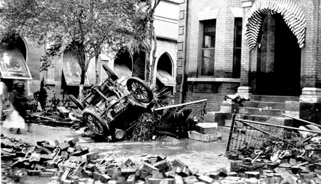
Downtown there was little loss of life yet the damage was considerable given the density of the built environment. Most of the bridges that crisscrossed the San Antonio River gave way, their foundations undercut by the swirling water’s erosive force or snapping before the pile-driving energy of trees, vehicles, and other flotsam, rampaging material that elsewhere took out foundations, punched in windows, and gouged out roadways. Commercial and civic buildings were flooded out; St. Mary’s Street Catholic Church, like many other facilities with limestone footings, would prove structurally unsound and would have to be torn down. The Bexar County courthouse was a mass of sodden paper, streetcar rail lines were twisted like pretzels, and massive maze-like mounds of busted furniture, beams, street pavers, and dead animals choked the grid. The city lay in ruins, a seeming war zone.
In time, San Antonio would dry out and rebuild, as would the other communities that had been submerged in 1921. All of them would invest in flood-control measures designed to prevent such extreme damage from occurring again (and these have worked more often than not). But as durable as these structures have been, they have also encouraged ever-more dense development within what once was identified as a flood zone (the Riverwalk is a classic example of this); and sanction construction of neighborhoods and shopping close to these protective structures (think the Quarry and environs). This new urban landscape’s vulnerability might be thoroughly exposed this summer should a major storm sweep up from the Gulf, channeling thick bands of tropical moisture along the high ground of the Balcones Escarpment. The resulting clash of deluge and drought, of wind-driven rains smacking into heat-hardened terrain might prove as fierce and fearsome as the swirling inferno now consuming vast stretches of central Texas.
Char Miller, who retired from Trinity University in 2009, is director of the environmental analysis program at Pomona College. He is author of Deep in the Heart of San Antonio, and editor of On the Border: An Environmental History of San Antonio and Cities and Nature in the American West.