

Bill Baird
Morningstar Boardwalk, a raised walkway that's part of the greenway system, allows pedestrians to pass without trampling the native meadow below.
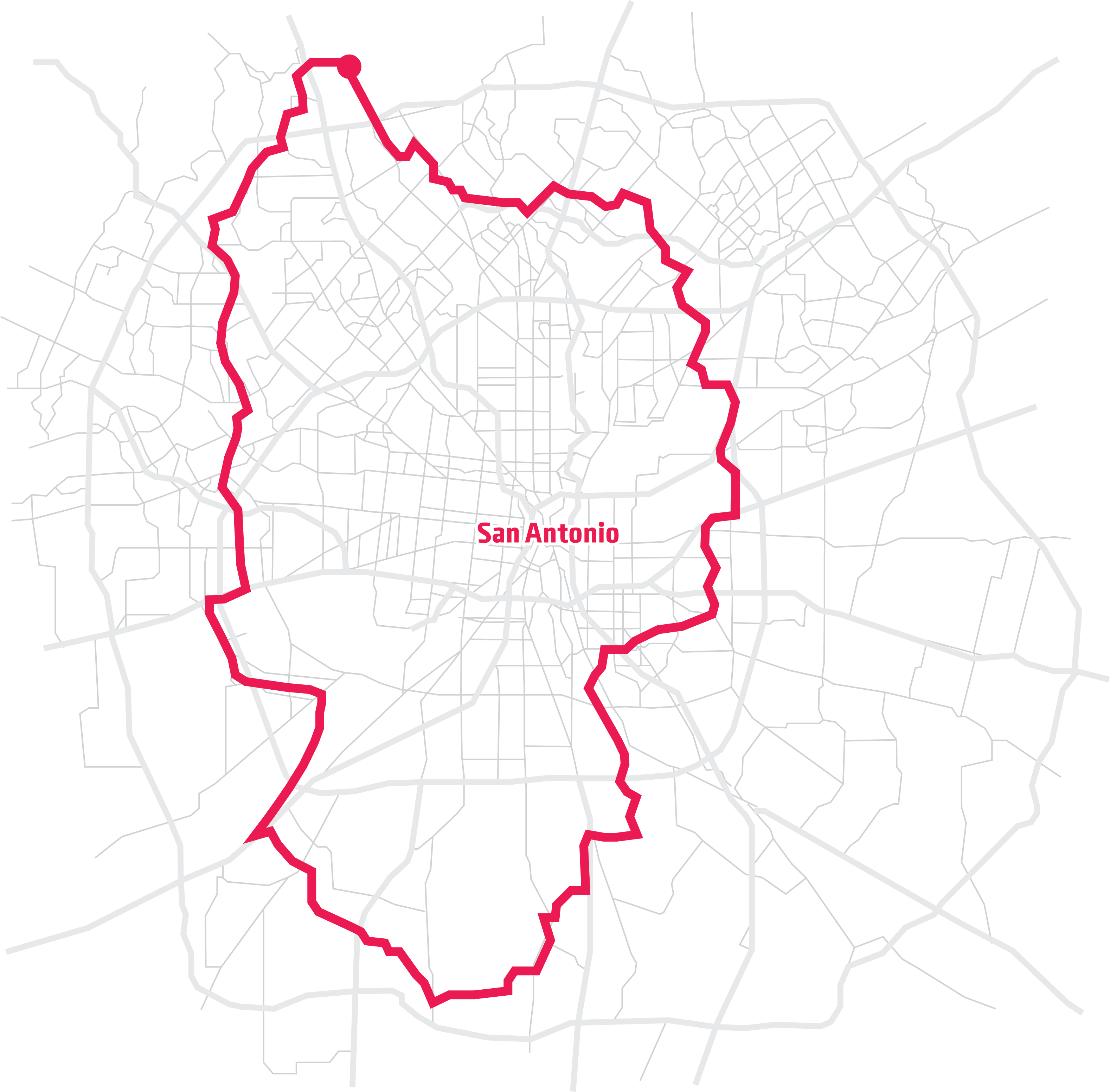
Several months and many miles ago, I set out to circumnavigate the city of San Antonio on foot. It seemed just crazy enough to be interesting.
Back in February, I began traversing the newly christened Howard W. Peak Greenway, which is wonderful but doesn’t fully encircle the city as seemingly advertised. So, where the trail ended, I trod under fences and through fields, sunk in slogs, squished into bogs and tramped through swamps.
Along the way — and as documented in periodic reports for the Current — I discovered that Leon Creek, the Medina River, the Mission Reach and lower Salado Creek all hold innumerable revelations, abundant fresh air and escape from the urban hustle.North Salado Creek was all that remained to finish my circuit around the city.
After completing the first stretches of my hike, my legs were sore, scratched and muddy, but thankfully both were still attached to my body. I’d sustained other minor injuries and scares in San Antonio’s far reaches — barbed wire nicked my pants a time or two and I dodged a few packs of dogs.
By comparison, I expected the final leg of my journey to be less dramatic. But, in a city renowned for its history, I figured that North Salado might have as much to offer as any other ground I traversed.
Overflowing delight
Heading north along Salado Creek from Comanche Park took me past a KOA, one of the few camping spots within SA’s city limits. Further north, I reached the boundary with Fort Sam Houston, one of the region’s most noteworthy repositories of history.
“We have more historic buildings than any other military base in America,” said Jackie Davis, director of Fort Sam’s base museum, who met me for a tour.
Fort Sam, before it was called that, was simply known as the Post at San Antonio, and was located at the Alamo. Eventually, however, it moved out of downtown for strategic reasons.
“Fort Sam is here precisely because of Salado Creek,” Davis said. “You’ve got water, plus you’re far enough from downtown so the soldiers can’t get into, um, shall we say, trouble in their downtime.”
The museum is an overflowing delight, located in the base’s quadrangle. Room after room shows the development of the post, from dusty outpost to modern military facility. A cannon, similar to those depicted on “Come and Take It” flags, sits in one room.
“I’d like to see you come and take it,” Davis said with a laugh. “This thing weighs thousands of pounds.”
This proposed extension of the Salado Creek Greenway passes through the base, but it doesn’t follow the creek due to the barracks located along the banks. Instead, it runs through the old horse corral and paddocks. While not perfect, the proposed path is an essential piece, connecting the greenway’s north and south stretches. Thank goodness the base and the city finally came together and worked out the kinks.
History along the trail
From Fort Sam, I walked north, passing the site of the Battle of Salado Creek, which occurred in 1842. The fight unfolded after the area had been recaptured by Mexican forces. Texas Ranger John Coffee “Jack” Hays and 14 other riders lured Mexican soldiers from the Alamo to the creek, where they were ambushed by Texans lying in wait. The victory was a pivotal moment in Texas’ fight for independence, and Hays later joined the California gold rush, becoming one of the first residents of the city of Oakland.
From there, my trek took me through Robert L.B. Tobin Park, a 100-acre portion of the towering arts patron’s estate, Oakwell, which was recently donated to be part of the Salado Creek Greenway.
Tobin was a legendary character with immense oil wealth and a pedigree that went all the way back to SA’s original Canary Islands settlers. He was one of the city’s great champions of the arts, known for his generous donations to the McNay Art Museum.
Tobin’s munificence wasn’t limited to the Alamo City, however. After a major dustup over the location of the medical center — Tobin wanted it downtown — he took his energy elsewhere, serving on the board of New York’s Museum of Modern Art and Metropolitan Opera. He also helped propel Santa Fe’s opera to worldwide renown.
“He and his mother were two of the most generous patrons of the arts I have ever known,’’ said Beverly Sills, chairwoman of Lincoln Center for the Performing Arts, in Tobin’s 2000 New York Times obituary.
To her point, the Tobin Endowment, founded after his death, has contributed more than $65 million to the arts, including a $15 million naming gift to build the Tobin Center for the Performing Arts.
We can do better
After walking through Tobin Park and the rocky cliffs below St. Mary’s Hall, my hike led to the Morningstar Boardwalk, a raised walkway allowing pedestrians to pass without trampling the native meadow below — one of the few I have seen in its natural, unmowed state. As I crossed the boardwalk, named for fallen Army Staff Sergeant Christopher Morningstar, the prickly pear cacti were in full bloom. It’s become one of my favorite spots in the city.
Farther along, I headed off trail, following the creek along the fence of San Antonio International Airport. Planes zoomed overhead and the wondrous blooms of wildflowers spread in front of me. Later, I trudged the two miles of greenway along Wurzbach Parkway. While I was happy to continue along the trail, I wondered if it’s really a greenway when you’re on a highway access road. We can do better.
However, the journey took me to Phil Hardberger Park, another highlight. Through this portion, Salado Creek is pocked with karst limestone, which filters San Antonio’s rainwater and fills its aquifer. The park’s newly opened land bridge set me fantasizing about similar bridges allowing me to visit my favorite local spots while skipping over sprawl, parking lots and strip malls. A green city, right on top of the old one.
Hey, it could happen.
Bloody, sweaty, random
At that point, I sensed my hike was near an end. My pace quickened. My legs were aching, throbbing, and my phone was dead. I had no money, food or water. I probably should have lost my Eagle Scout designation over my poor planning, but hey, I was trying.
I continued, jogging by the Medicine Wall, a newly opened rock-climbing wall that was rugged and wonderful and completely unexpected.
North of 1604, the trail squeezed between Camp Bullis and the Martin Marietta-Beckmann quarry. Seen through its chain-link fence, the quarry was about as beautiful and dramatic a vision as I’ve seen anywhere. For the love of Texas, please turn this stunning site into a public access park once it’s outlived its use as a quarry, and not another landfill. It’s like the canyonlands, right in our backyard.
From there, it was only a couple miles back to my starting point at The Rim, but the greenway’s connecting portion to Eisenhower Park was still under construction. Numerous signs told me so. Since I had a ride picking me up there in an hour, I ducked under the orange tape and sprinted around the construction crews, through cedar breaks, panting, sweating, bleeding and confused.
“Can I get to The Rim from here?” I asked a hiker I encountered along the way.
She looked at me like the bloody, sweaty, random dude I was, and said, “Don’t think so.” She moved along quickly. Can’t say I blame her.
I dodged the construction crew, avoided falling into the quarry and stumbled back to where I’d started my circumnavigation — weary but transformed. There’s something magical about hiking a long loop — you end up right back where you started, but somehow, your perception is different. You change your eyes; you change your understanding of your surroundings.
I stumbled into a Holiday Inn and the lobby clerk, taking pity on me, gave me an orange and allowed me to make a phone call. My journey was complete!
Outer limits
Hiking the entire outer perimeter of San Antonio expanded my mind, blew out my shoes, sunburned my face and pulled back the curtain on our city’s rich history.
It also exposed wide gaps in the Howard Peak Greenway’s proposed series of connected trails. There are still 71 miles to go at an estimated cost of $279 million. Will the gaps be filled?
It remains to be seen.
The 1/8-cent sales tax that funded the Peak Greenway was approved by voters four times since 2000. However, it’s since been reallocated to fund career training and VIA Metropolitan Transit. Yes, that means funding initially approved for open space and nature access has gone to more vehicles on the roads.
My hike around San Antonio has convinced me that we all need to call our city representatives and tell them to restore funding for our greenways. Let’s complete the system of trails once envisioned as an “emerald necklace” and build a remarkable 21st century city.
Stay on top of San Antonio news and views. Sign up for our Weekly Headlines Newsletter.
