Join 30,000 locals who stay current on San Antonio news, culture, and events. Get our free newsletters in your inbox three times a week.
Don’t Miss a Moment.
Join 30,000 locals who stay current on San Antonio news, culture, and events. Get our free newsletters in your inbox three times a week.
San Antonio’s continued development and growth means that the local scenery changes dramatically each year — and the city is downright unrecognizable compared to how it looked 15 years ago.
Some of the changes have been for the better, but others less so. On the plus side, the River Walk and other local landmarks have gotten makeovers, enriching the city’s cultural landscape.
While the SA food scene also seems to get better and better annually, there have been some notable losses just the same. And sure, there are more downtown living options, but housing costs continue to rise at an alarming rate.
Here’s a before-and-after look at how San Antonio has changed since the late 2000s.
Then – 2007
Former St. Scholastica Convent
1111 S. Alamo St. Credit: Photo via Google MapsNow – 2022
Liberty Bar
1111 S. Alamo St. Credit: Photo via Google MapsThen – 2007
Warehouse
150 Camp St. Credit: Photo via Google MapsNow – 2022
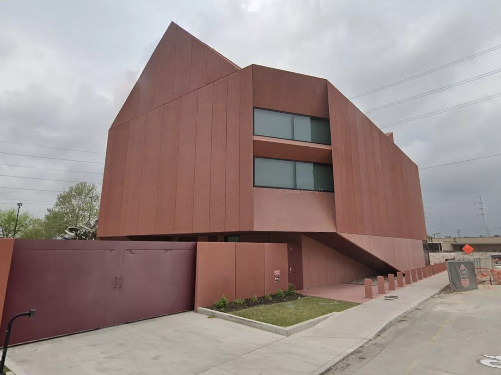
Ruby City
150 Camp St. Credit: Photo via Google MapsWhite Rabbit
Much like Paper Tiger, its successor on the St. Mary’s Strip, the White Rabbit was a club where local bands could open for nationally touring acts that had outgrown small clubs but weren’t yet playing concert halls. Bands that played there included Primus, They Might Be Giants, The Melvins, Henry Rollins, Wayne Kramer and more. Credit: Photo via Google MapsNow – 2022
Paper Tiger
2410 N. St. Mary’s St. Credit: Photo via Google MapsThen – 2007
Jacala
606 West Ave. Credit: Photo via Google MapsNow – 2022
Empty Lot
606 West Ave. Credit: Photo via Google MapsThen – 2007
Paved Lot
310 W. Mitchell St. Credit: Photo via Google MapsNow – 2022
Confluence Park
310 W. Mitchell St. Credit: Photo via Google MapsThen – 2007
Vacant House
1009 Avenue B Credit: Photo via Google MapsNow – 2022
El Camino
1009 Avenue B Credit: Photo via Google MapsThen – 2007
Hays Street Bridge
803 N. Cherry St. Credit: Photo via Google MapsNow – 2022
Hays Street Bridge
803 N. Cherry St. Credit: Photo via Google MapsThen – 2007
Vacant Building
915 Dallas St. Credit: Photo via Google MapsNow – 2022
San Antonio Current Office
915 Dallas St. Credit: Photo via Google MapsThen – 2007
Enchilada Warehouse & Cantina
2114 N. St. Mary’s St. Credit: Photo via Google MapsNow – 2022
Lonesome Rose
2114 N. St. Mary’s St. Credit: Photo via Google MapsThen – 2007
Blue Star Arts Complex
1414 S. Alamo St. Credit: Photo via Google MapsNow – 2022
Blue Star Arts Complex
1414 S. Alamo St. Credit: Photo via Google MapsThen – 2011
Residence
302 Montana St. Credit: Photo via Google MapsNow – 2022
Cherrity Bar
302 Montana St. Credit: Photo via Google MapsThen – 2007
Municipal Auditorium
100 Auditorium Circle Credit: Photo via Google MapsNow – 2022
Tobin Center for the Performing Arts
100 Auditorium Circle Credit: Photo via Google MapsThen – 2007
Pearl Brewery
136 E. Grayson St. Credit: Photo via Google MapsNow – 2022
Hotel Emma, The Pearl
136 E. Grayson St. Credit: Photo via Google MapsThen – 2007
The Beach
231 E. Cevallos St. Credit: Photo via Google MapsNow – 2022
Dos Sirenos Brewing
231 E. Cevallos St. Credit: Photo via Google MapsThen – 2007
Parking Lot
111 W. Houston St. Credit: Photo via Google MapsNow – 2022
Frost Tower
111 W. Houston St. Credit: Photo via Google MapsThen – 2007
San Pedro Creek
715 Camaron St. Credit: Photo via Google MapsNow – 2022
San Pedro Creek Culture Park
715 Camaron St. Credit: Photo via Google MapsThen – 2007
Broadway News
2202 Broadway Credit: Photo via Google MapsNow – 2022
Broadway News
2202 Broadway Credit: Photo via Google MapsThen – 2007
Car Dealership
2800 Broadway Credit: Photo via Google MapsNow – 2022
The DoSeum
2800 Broadway Credit: Photo via Google MapsThen – 2007
Krazy Kat Music
3020 N. St. Mary’s St. Credit: Photo via Google MapsNow – 2022
Plant Shoppe and Ink Couture Tattoos
3020 N. St. Mary’s St. Credit: Photo via Google MapsThen – 2007
Kress Building
311-315 E. Houston St. Credit: Photo via Google MapsNow – 2022
Kress Building
311-315 E. Houston St. Credit: Photo via Google MapsThen – 2008
Former Peden Iron & Steel Co.
1401 S. Flores St. Credit: Photo via Google MapsNow – 2022
Steel House Lofts
1401 S. Flores St. Credit: Photo via Google MapsThen – 2007
San Antonio River
510 Brooklyn Ave. Credit: Photo via Google MapsNow – 2022
San Antonio River Lock & Dam
510 Brooklyn Ave. Credit: Photo via Google MapsThen – 2007
Southtown Cafe
1127 S. St. Mary’s St. Credit: Photo via Google MapsNow – 2022
The Good Kind Southtown
1127 S. St. Mary’s St. Credit: Photo via Google MapsThen – 2007
Retail Storefront
2720 McCullough Ave. Credit: Photo via Google MapsNow – 2022
Barbaro
2720 McCullough Ave. Credit: Photo via Google MapsThen – 2007
Former Riata Cadillac Dealership
317 Lexington Ave. Credit: Photo via Google MapsNow – 2022
Cadillac Lofts
317 Lexington Ave. Credit: Photo via Google Maps