Severe Weather Possible Tonight, Tomorrow Morning

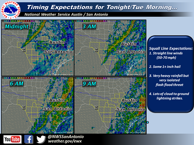
The National Weather Service reports that an upper level system and cold front could create strong to severe storms Monday night through Tuesday morning.

"The Hill Country including the Austin and San Antonio areas are under a slight risk of severe weather," according to NWS.

Meteorologists warn that damaging winds and large hail are the main threats, and that they can't rule out an "isolated tornado or two."

The NWS reports that there could be "moderate to heavy rains" but that flash flooding isn't a huge threat because the front is moving fast.

Here is our latest multimedia briefing over the upcoming weather. http://www.youtube.com/watch?v=gpNta1mdfKo

Posted by US National Weather Service Austin-San Antonio Texas on Monday, November 16, 2015

KEEP SA CURRENT!

Since 1986, the SA Current has served as the free, independent voice of San Antonio, and we want to keep it that way.

Becoming an SA Current Supporter for as little as $5 a month allows us to continue offering readers access to our coverage of local news, food, nightlife, events, and culture with no paywalls.

Join today to keep San Antonio Current.

Scroll to read more San Antonio News articles

Join SA Current Newsletters

Subscribe now to get the latest news delivered right to your inbox.